-
 ×
- Domů
- Umělecké Tisky ▸
- Umělci ▸
- Kategorie ▸
- Výtvarné Styly ▸
- Obrazový rám ▸
- Tiskové médium ▸
- Všechna tisková média
- Plátno Leonardo (satén)
- Plátno Salvador (matné)
- Plátno Raphael (matné)
- Matný umělecký fotopapír
- Saténový umělecký fotopapír
- Barytový umělecký fotopapír
- Lesklý umělecký fotopapír
- Akvarel lepenka Munch
- Akvarel lepenka Renoir
- Akvarel lepenka Turner
- Akvarel lepenka Dürer
- Natural Line Hemp
- Natural Line Rice
- Kozo White, 110g
- Kozo Natural, 110g
- Inbe White, 125g
- Unryu, 55g
- Bamboo, 110g
- Premio Unryu, 165g
- Murakumo Natural, 42g
- Bizan Natural, 300g
- Bizan White, 300g
- Hliníkový kompozit 3mm
- Akrylátové sklo 5mm
- Objednat sadu vzorků
- Které tiskové médium se hodí?
Plátno
Fotopapír
Akvarelový karton
Natural Line
Japonský papír
Speciální média
Další informace
- Pomoc a servis ▸
- Kontaktujte nás
- Prodejte své umění
- Často kladené otázky
- Volná místa
- Reklamace
- Objednat vzorky
- Objednat poukázky
- Náklady na dopravu
- Doba výroby
- Udržitelnost
- Vyhledávání obrázků
- Zvláštní požadavky
- Kdo jsme?
- Cenová politika
- Firemní politika
- Záruka kvality
- Ocenění
- Napínací rám
- Pasparty
- Dekorativní rámy
- Zasklení
- Lišty
- Závěsné systémy
- Tisková média
- Tipy na údržbu
- Tisk
- Obchodní podmínky
- Ochrana údajů
- Právo na zrušení
Informace a služby
Další informace
Důležité informace
Právní informace
- Obchod ▸
- Kontakt


 Zobrazit ve 3D / AR
 Přidat do oblíbených
 Zvolte barvu stěny
 Zobrazit obraz v místnosti
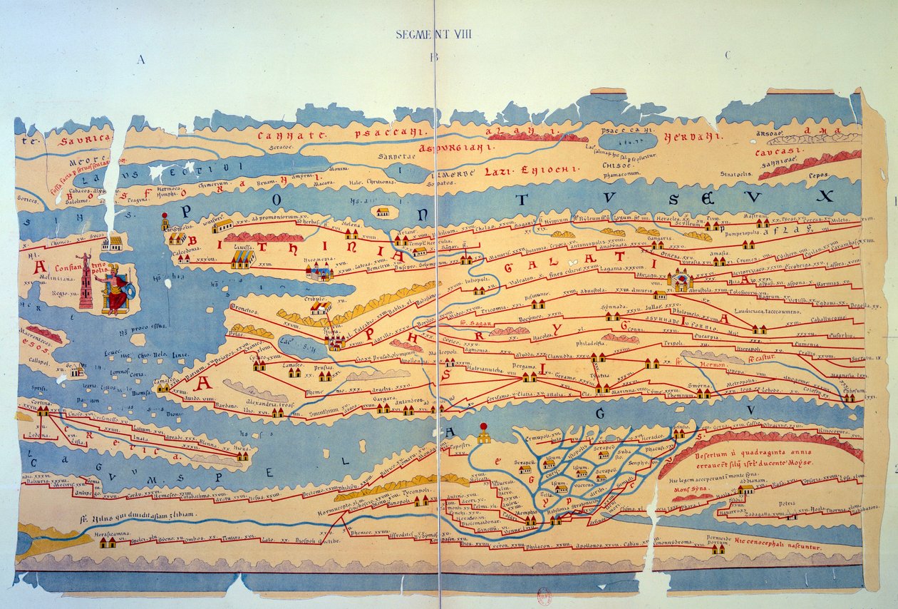
.jpg "Detail Konstantinopole a Blízkého východu z kopie Peutingerovy mapy")
.jpg "Detail Itálie z kopie Peutingerovy mapy")
 an illustrated itinerarium of the road network in the Roman EmpireDetail of Italy from the Peutinger map copy - (MeisterDrucke-110655).jpg "Část Tabula Peutingeriana (Peutingerova tabule, Peutingerova mapa), ilustrovaný itinerář silniční sítě v Římské říši. Detail Itálie z kopie Peutingerovy mapy")

 - (MeisterDrucke-101695).jpg "Mapa střední Evropy, 1486 (detail z 157909)")


.jpg "Kopie Beatusovy mapy světa z 8. století")

.jpg "Heilbronn a jeho východní okolí 1578")
.jpg "Detail Konstantinopole z kopie mapy Peutinger")
.jpg "Mapa Afriky, tabule 18 ze světového atlasu, 1486")


.jpg "Ms. Arabe 2221, fol. 203 a 204, mapa Středozemního moře, Evropy a Afriky, 1300")
.jpg "Mapa Francie, z „Geographia“")
.jpg "Detail římské Galie z kopie mapy Peutinger")
.jpg "Svatá země, z Atlasu světa ve 33 mapách, Benátky, 1. září 1553 (inkoust na pergamenu) (viz také 330965)")

.jpg "Geologická mapa [of] Manhattan Island of New York, 1842 (ručně kolorovaná litografie připevněná na papíře)")
 (see also 330964) - (MeisterDrucke-102741).jpg "Blízký východ z atlasu světa ve 33 mapách, Benátky, 1. září 1553")
.jpg "Mapa Kliverova švu v oblasti údolí Ruhbachu")


 - (MeisterDrucke-676887).jpg "Bavorské venkovské stoly z roku 1568 (panel 10)")
.jpg "Plán a pohled na bitvu u Waterloo s postavením Angličanů červeně, Belgičanů žlutě, Prusů zeleně a Francouzů modře")


 published in Paris 1835 - (MeisterDrucke-174765).jpg "Alegorický frontispis Říma a jeho dějin, z díla „Le Antichità Romane de G.B. Piranesi (1756)“, vydáno v Paříži, 1835")
.jpg "Květiny v křišťálové váze, kolem roku 1882")
 Water-Lilies - (MeisterDrucke-21577).jpg "Lekníny („Žlutá nirvána“)")

.jpg "Jachta přibližující se k pobřeží")

 - (MeisterDrucke-44855).jpg "Snídaně v trávě")
.jpg "Růžový broskvoň, 1888")

.jpg "Jezírko s lekníny")
.jpg "Rybáři na moři")
 1922 - (MeisterDrucke-647283).jpg "Modrá, 1922")
.jpg "Umění malby")
.jpg "Topoly na Seině")

 +43 4257 29415
 support@meisterdrucke.com
 Mo-Do: 7:00 - 16:00 | Fr: 7:00 - 13:00